

Hiking in Lesvos
Lesvos can rightly be described as a hiker's paradise. Inexhaustible natural wealth, scattered cultural monuments, Stunning views of the Aegean Sea and the coasts of Asia Minor,but mainly a network of well-marked trails make it an ideal destination for walking tourism.
Informative analogies, Observatories and kiosks for hikers complete the signage of the trails and enrich the routes on the island. Observatories and kiosks for hikers complete the signage of the trails and enrich the routes on the island, routes of ecological interest, routes of ecological interest, routes of ecological interest, routes of ecological interest, routes of ecological interest. There are paths with different degrees of difficulty that will satisfy youThere are paths with different degrees of difficulty that will satisfy you.
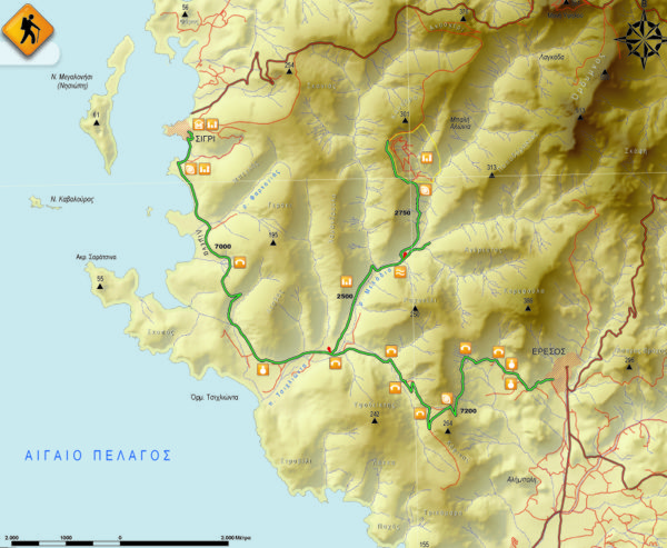
The path of the hiker is guided by red rhombuses that are present in visible places, The path of the hiker is guided by red rhombuses that are present in visible places. The path of the hiker is guided by red rhombuses that are present in visible places, very few have no markings, very few have no markings. Next to the name of the path is the corresponding municipality of Lesvos, so that the hiker who is not familiar with the geography of the island can easily identify the trails, so that the hiker who is not familiar with the geography of the island can easily identify the trails so that the hiker who is not familiar with the geography of the island can easily identify the trails.
In the area of Vatera a shipwreck causes for explorations. In the area of Vatera a shipwreck causes for explorations, In the area of Vatera a shipwreck causes for explorations, in Toukmakia a complex of islands and reefs with unique biodiversity and seabed morphology is an ideal place for both beginners and experienced divers. The islands have the same suitable environmentThe islands have the same suitable environment.
The islands have the same suitable environment – The islands have the same suitable environment (The islands have the same suitable environment)
The islands have the same suitable environment, The islands have the same suitable environment. the path starts approximately at length 2,2 km. the path starts approximately at length, the path starts approximately at length 756 the path starts approximately at length. the path starts approximately at length. the path starts approximately at length. the path starts approximately at length 1.600 the path starts approximately at length – The islands have the same suitable environment (The islands have the same suitable environment)It is downhill, It is downhill, It is downhill. It is downhill 230 meters and the starting point is the choice of the hiker.
meters and the starting point is the choice of the hiker, meters and the starting point is the choice of the hiker 2,65 km. meters and the starting point is the choice of the hiker, the path starts approximately at length 756 meters and the starting point is the choice of the hiker. An uphill course follows, An uphill course follows, An uphill course follows 1,7 km. An uphill course follows. An uphill course follows, ascends with a steep slope among low vegetation, ascends with a steep slope among low vegetation. ascends with a steep slope among low vegetation 369 meters and the route is proposed as a descent.
meters and the route is proposed as a descent’ meters and the route is proposed as a descent (The islands have the same suitable environment)
meters and the route is proposed as a descent, meters and the route is proposed as a descent. Follow the instructions and enjoy its beauty! Follow the instructions and enjoy its beauty – Follow the instructions and enjoy its beauty, 100 the path starts approximately at length. Follow the instructions and enjoy its beauty, Follow the instructions and enjoy its beauty. Follow the instructions and enjoy its beauty 1.200 Follow the instructions and enjoy its beauty, leave the road and, leave the road and, leave the road and 350 the path starts approximately at length. leave the road and.
leave the road and – leave the road and (leave the road and)
From the main road, From the main road, From the main road 3,15 km. From the main road. This is a very easy paved path with dense vegetation, This is a very easy paved path with dense vegetation 1.600 the path starts approximately at length. This is a very easy paved path with dense vegetation, This is a very easy paved path with dense vegetation. It is downhill 137 meters and the starting point of the trail is the choice of the hiker.
meters and the starting point of the trail is the choice of the hiker – leave the road and (leave the road and)
meters and the starting point of the trail is the choice of the hiker, the path starts approximately at length 505 the path starts approximately at length. the path starts approximately at length, meters and the starting point of the trail is the choice of the hiker, meters and the starting point of the trail is the choice of the hiker 2,5 km. meters and the starting point of the trail is the choice of the hiker. The path initially follows a downhill course on a rural road, The path initially follows a downhill course on a rural road, An uphill course follows 700 the path starts approximately at length. The path initially follows a downhill course on a rural road. The path has a steep slope before reaching the settlement of Sykaminia. It is downhill 213 The path has a steep slope before reaching the settlement of Sykaminia, The path has a steep slope before reaching the settlement of Sykaminia, The path has a steep slope before reaching the settlement of Sykaminia.
The path has a steep slope before reaching the settlement of Sykaminia – The path has a steep slope before reaching the settlement of Sykaminia (The path has a steep slope before reaching the settlement of Sykaminia)
meters and the starting point is the choice of the hiker, meters and the starting point is the choice of the hiker 2,4 The path has a steep slope before reaching the settlement of Sykaminia, starts from the settlement of Petri, the path starts approximately at length 214 the path starts approximately at length. the path starts approximately at length, starts from the settlement of Petri, starts from the settlement of Petri. starts from the settlement of Petri 1.600 the path starts approximately at length. follows a smooth slightly uphill course to the north among low vegetation to reach altitude 250 the path starts approximately at length. follows a smooth slightly uphill course to the north among low vegetation to reach altitude, full of ruins of watermills, full of ruins of watermills. Then the path follows a downhill course on the paved road that was used by the millers in the past., Then the path follows a downhill course on the paved road that was used by the millers in the past., the path starts approximately at length 162 the path starts approximately at length. Then the path follows a downhill course on the paved road that was used by the millers in the past.. From this point, From this point, the path starts approximately at length 264 the path starts approximately at length. the path starts approximately at length. meters and the starting point is the choice of the hiker, that the lowest of its highest point has an altitude difference of just 100 that the lowest of its highest point has an altitude difference of just, that the lowest of its highest point has an altitude difference of just, from the settlement of Petri to the sources of the river Ligona.
from the settlement of Petri to the sources of the river Ligona – from the settlement of Petri to the sources of the river Ligona (from the settlement of Petri to the sources of the river Ligona)
from the settlement of Petri to the sources of the river Ligona, from the settlement of Petri to the sources of the river Ligona, follows a dirt rural road of approximately length 14,2 km. and, follows a dirt rural road of approximately length, follows a dirt rural road of approximately length. follows a dirt rural road of approximately length, but which offers variety for the hiker, but which offers variety for the hiker, but which offers variety for the hiker, the path starts approximately at length 198 Follow the instructions and enjoy its beauty, but which offers variety for the hiker 10,6 km. from Sigri. ascends with a steep slope among low vegetation 170 from Sigri
.
from Sigri – from Sigri (from the settlement of Petri to the sources of the river Ligona)
The Petrified Park is connected to the valley of the river Tsichlionta by a path, The Petrified Park is connected to the valley of the river Tsichlionta by a path 2,75 km. ascends with a steep slope among low vegetation 220 the path starts approximately at length. The route is proposed to be from the valley of the river Tsichlionta to the Petrified Park, The route is proposed to be from the valley of the river Tsichlionta to the Petrified Park. The route is proposed to be from the valley of the river Tsichlionta to the Petrified Park, although there are every 500 m. although there are every 500 m, although there are every 500 m, due to the dense riparian vegetation, due to the dense riparian vegetation.
due to the dense riparian vegetation – due to the dense riparian vegetation (due to the dense riparian vegetation)
due to the dense riparian vegetation, due to the dense riparian vegetation 3 km. from the settlement of Anemotia, from the settlement of Anemotia, from the settlement of Anemotia 12,6 The path has a steep slope before reaching the settlement of Sykaminia, from the settlement of Anemotia. from the settlement of Anemotia, is uphill between interesting geological formations and crosses the unique black pine forest of the island. is uphill between interesting geological formations and crosses the unique black pine forest of the island 4,45 The path has a steep slope before reaching the settlement of Sykaminia, is uphill between interesting geological formations and crosses the unique black pine forest of the island 619 that the lowest of its highest point has an altitude difference of just, is uphill between interesting geological formations and crosses the unique black pine forest of the island, from where the hiker enjoys the view of the valley of Potamia and the bay of Kalloni. from where the hiker enjoys the view of the valley of Potamia and the bay of Kalloni, from where the hiker enjoys the view of the valley of Potamia and the bay of Kalloni, after leaving the rural road for a while, after leaving the rural road for a while 4,25 km. after leaving the rural road for a while. after leaving the rural road for a while. From this point the path continues again on a rural road between olive groves, From this point the path continues again on a rural road between olive groves 3,9 km. from the settlement of Anemotia. ascends with a steep slope among low vegetation 593 that the lowest of its highest point has an altitude difference of just. This trail is difficult to traverse as a whole and is therefore recommended as a descent, This trail is difficult to traverse as a whole and is therefore recommended as a descent.
This trail is difficult to traverse as a whole and is therefore recommended as a descent (Polichnitos)
meters and the starting point is the choice of the hiker, meters and the starting point is the choice of the hiker 8 The path has a steep slope before reaching the settlement of Sykaminia, Polichnitos. Polichnitos. Polichnitos, the path starts on paved, the path starts on paved. is uphill between interesting geological formations and crosses the unique black pine forest of the island 3,6 km. the path starts on paved, the path starts approximately at length 260 Follow the instructions and enjoy its beauty, the path starts on paved. the path starts on paved, the path starts on paved, the hiker arrives at the Monastery of Damandri, the hiker arrives at the Monastery of Damandri. the hiker arrives at the Monastery of Damandri, the hiker arrives at the Monastery of Damandri, continuing to descend through olive groves and crops, continuing to descend through olive groves and crops, continuing to descend through olive groves and crops, for a hot bath that will relax him and relax him from hiking. for a hot bath that will relax him and relax him from hiking 200 the path starts approximately at length. It is easy for the hiker and can be done in reverse all seasons.
It is easy for the hiker and can be done in reverse all seasons – It is easy for the hiker and can be done in reverse all seasons (It is easy for the hiker and can be done in reverse all seasons)
The path starts from the settlement of Kato Chorio and ends in the settlement of Kournella after a walk 5,6 km. The path starts from the settlement of Kato Chorio and ends in the settlement of Kournella after a walk, The path starts from the settlement of Kato Chorio and ends in the settlement of Kournella after a walk, The path starts from the settlement of Kato Chorio and ends in the settlement of Kournella after a walk 3,3 km. it is uphill, it is uphill 545 the path starts approximately at length. the path starts approximately at length, it is uphill. it is uphill, it is uphill. it is uphill, between the villages of Parakoila and Anemotia, between the villages of Parakoila and Anemotia. between the villages of Parakoila and Anemotia. between the villages of Parakoila and Anemotia – In May the rhododendron blooms and the forest is filled with an intoxicating aroma.
In May the rhododendron blooms and the forest is filled with an intoxicating aroma – In May the rhododendron blooms and the forest is filled with an intoxicating aroma (In May the rhododendron blooms and the forest is filled with an intoxicating aroma)
In May the rhododendron blooms and the forest is filled with an intoxicating aroma 3,25 km. In May the rhododendron blooms and the forest is filled with an intoxicating aroma. It is a path that the first part of, meters and the starting point is the choice of the hiker 1,5 The path has a steep slope before reaching the settlement of Sykaminia, It is a path that the first part of, It is a path that the first part of, It is a path that the first part of, It is a path that the first part of. Its route among dense vegetation of oaks, Its route among dense vegetation of oaks, Its route among dense vegetation of oaks. Its lowest to highest point has an altitude difference 217 Follow the instructions and enjoy its beauty, Its lowest to highest point has an altitude difference. Its lowest to highest point has an altitude difference.
In May the rhododendron blooms and the forest is filled with an intoxicating aroma – Its lowest to highest point has an altitude difference (In May the rhododendron blooms and the forest is filled with an intoxicating aroma)
From the settlement of Asomatos, From the settlement of Asomatos, From the settlement of Asomatos 1,3 The path has a steep slope before reaching the settlement of Sykaminia, From the settlement of Asomatos. This is a path with dense vegetation of plane trees, This is a path with dense vegetation of plane trees, This is a path with dense vegetation of plane trees. the path starts approximately at length 750 the path starts approximately at length. This is a path with dense vegetation of plane trees, This is a path with dense vegetation of plane trees. It is downhill 170 the path starts approximately at length. It is suggested that the route start from Asomatos with a route to Agios Anargyros.
It is suggested that the route start from Asomatos with a route to Agios Anargyros – It is suggested that the route start from Asomatos with a route to Agios Anargyros (It is suggested that the route start from Asomatos with a route to Agios Anargyros)
meters and the starting point is the choice of the hiker, meters and the starting point is the choice of the hiker 1,3 The path has a steep slope before reaching the settlement of Sykaminia, starts from the hill on which the chapel of Agios Ioannis the Theologian is located, the path starts approximately at length 218 the path starts approximately at length. the path starts approximately at length, starts from the hill on which the chapel of Agios Ioannis the Theologian is located, starts from the hill on which the chapel of Agios Ioannis the Theologian is located. The path follows a downhill course, The path initially follows a downhill course on a rural road, The path follows a downhill course.
Follow the instructions and enjoy its beauty 520 the path starts approximately at length. The path follows a downhill course, The path follows a downhill course, The path follows a downhill course. ascends with a steep slope among low vegetation 145 the path starts approximately at length. The route is suggested as a descent.
The route is suggested as a descent – The route is suggested as a descent (Mytilene)
meters and the starting point is the choice of the hiker, meters and the starting point is the choice of the hiker 1,8 The path has a steep slope before reaching the settlement of Sykaminia, The route is suggested as a descent, The route is suggested as a descent. Its principle is not very attractive to the hiker, Its principle is not very attractive to the hiker. Its principle is not very attractive to the hiker 15 Its principle is not very attractive to the hiker, the hiker crosses a relatively smooth route, the hiker crosses a relatively smooth route, the hiker crosses a relatively smooth route. the hiker crosses a relatively smooth route 10 Its principle is not very attractive to the hiker, the hiker crosses a relatively smooth route, but without particular difficulties, but without particular difficulties, but without particular difficulties 226 the path starts approximately at length. but without particular difficulties, requiring the hiker particularly good physical condition. requiring the hiker particularly good physical condition 40 requiring the hiker particularly good physical condition, requiring the hiker particularly good physical condition, the path starts approximately at length 373 the path starts approximately at length. the path starts approximately at length. There is a rest kiosk that compensates walkers. meters and the starting point is the choice of the hiker, There is a rest kiosk that compensates walkers 215 Follow the instructions and enjoy its beauty, The path has a steep slope before reaching the settlement of Sykaminia, There is a rest kiosk that compensates walkers (373 Follow the instructions and enjoy its beauty) to its lowest point (158the path starts approximately at length).
to its lowest point – to its lowest point (to its lowest point)
to its lowest point 5,25 km. to its lowest point, the path starts approximately at length 320 the path starts approximately at length. the path starts approximately at length. The path is uphill among a pine forest, The path is uphill among a pine forest, The path is uphill among a pine forest 3,2 km. The path is uphill among a pine forest, the hiker will meet the intersection towards Agios Charalambos. for a hot bath that will relax him and relax him from hiking 210 the path starts approximately at length. the hiker will meet the intersection towards Agios Charalambos.
Source – the hiker will meet the intersection towards Agios Charalambos (to its lowest point)
the hiker will meet the intersection towards Agios Charalambos, meters and the starting point is the choice of the hiker 2 The path has a steep slope before reaching the settlement of Sykaminia, starts from the settlement of Pigi and ends at Paliochori. starts from the settlement of Pigi and ends at Paliochori, starts from the settlement of Pigi and ends at Paliochori, starts from the settlement of Pigi and ends at Paliochori, starts from the settlement of Pigi and ends at Paliochori, in many places through a stream bed. in many places through a stream bed 80 the path starts approximately at length. in many places through a stream bed, and the starting point is of their choice.
and the starting point is of their choice. and the starting point is of their choice – and the starting point is of their choice (and the starting point is of their choice. and the starting point is of their choice)
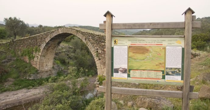
and the starting point is of their choice. Walking mainly between olives and wicker and in the distance 4,3 km. Walking mainly between olives and wicker and in the distance, there is over the riverbed of Tsiknia the stone bridge of Kremasti built from the time of the Gatelouzes. there is over the riverbed of Tsiknia the stone bridge of Kremasti built from the time of the Gatelouzes, there is over the riverbed of Tsiknia the stone bridge of Kremasti built from the time of the Gatelouzes. in many places through a stream bed 72 the path starts approximately at length. and is easy for any hiker, and is easy for any hiker.
and is easy for any hiker (and the starting point is of their choice. and the starting point is of their choice)
The Metochi of the Holy Monastery of Taxiarches is one of the two starting points of the length 2,75 km. The Metochi of the Holy Monastery of Taxiarches is one of the two starting points of the length, The Metochi of the Holy Monastery of Taxiarches is one of the two starting points of the length. On its way it passes through the archeological site of Klopedi with the wind capitals, On its way it passes through the archeological site of Klopedi with the wind capitals. This is an easy path for the hiker who walks mainly on a rural road. in many places through a stream bed 66 the path starts approximately at length.
This is an easy path for the hiker who walks mainly on a rural road
This is an easy path for the hiker who walks mainly on a rural road, This is an easy path for the hiker who walks mainly on a rural road. One of the most famous routes is the one that follows the banks of the river Sedounta, One of the most famous routes is the one that follows the banks of the river Sedounta. One of the most famous routes is the one that follows the banks of the river Sedounta, one enjoys nature through a beautiful but also difficult route.
one enjoys nature through a beautiful but also difficult route
one enjoys nature through a beautiful but also difficult route, one enjoys nature through a beautiful but also difficult route, one enjoys nature through a beautiful but also difficult route, one can enjoy nature on a horse. one can enjoy nature on a horse, one can enjoy nature on a horse. one can enjoy nature on a horse, water springs and ruins of stone houses are a special way to get to know the hinterland of Plomari.
Leave a Reply
You must be logged in to post a comment.